Address
Studio 03
SUM Studios
1 Hartley Street
Sheffield
S2 3AQ
[email protected]
0114 399 1023
Construction is a fast-moving, high-stakes industry where precise tracking of site progress can be the difference between staying on schedule or facing costly delays. Traditional reporting methods, such as photos, spreadsheets, and written site logs, often fall short in delivering real-time accuracy, transparency, and spatial context. That’s where point cloud scanning surveys are changing the game.
At Scene3D, we specialise in using cutting-edge scanning technology to support construction firms in creating detailed, visual, and interactive progress reports that everyone,—from project managers to stakeholders,—can understand at a glance. In this blog, we’ll explore how 3D scanning fits into modern construction workflows and why it’s quickly becoming the new standard for site reporting.
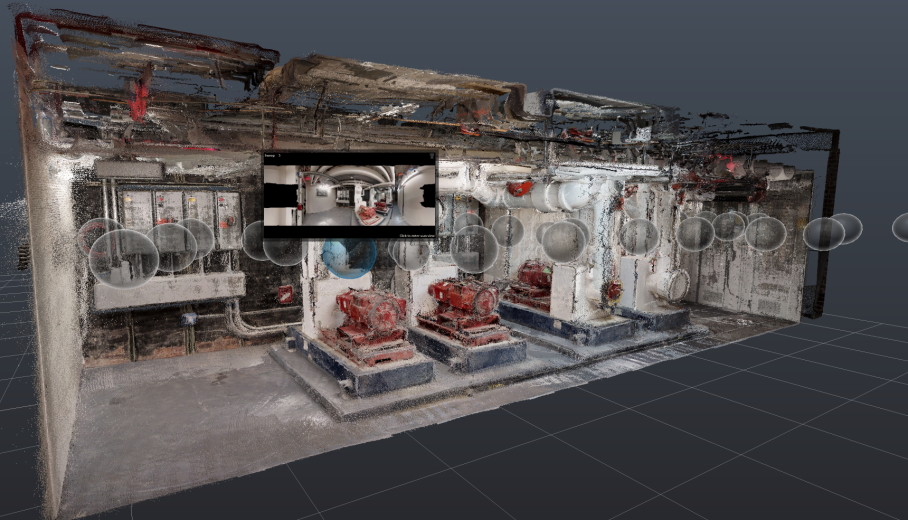
Point cloud surveys in construction involve using laser scanners to capture the physical environment of a construction site in exact detail. The data is then turned into a 3D model.
Unlike static photos, 3D scans capture every angle and dimension of the construction site. You can walk through the space, zoom in on details, and compare the latest scan to previous ones to assess real progress. Read our full guide to point cloud surveys.
One of the biggest challenges in construction project management is maintaining clear communication between stakeholders. Project owners, architects, site supervisors, and subcontractors often rely on inconsistent updates and disconnected media.
Point cloud surveys solve this by offering:

Our team at Scene3D coordinates with the site manager to conduct the scans at agreed project milestones. A typical scanning session takes just a few hours, depending on site size, and causes minimal disruption to on-site work.
Once the scan is complete, we process and deliver a fully navigable 3D model within 24–48 hours. We can also integrate key features such as:
These models are then easily accessible via a secure URL that can be embedded in reports or shared with stakeholders.
Point cloud scanning is not just for documentation. It offers long-term value across several phases of the project:
The benefits extend well beyond the construction phase. Facilities managers often refer to these scans years later to understand the layout of mechanical and electrical systems hidden behind walls.

Typical site progress reports rely heavily on manual input, selective photography, and subjective descriptions. While helpful, these methods often miss critical context and can lead to miscommunication or disputes.
For example, a photo might show a completed wall,—but it won’t reveal alignment issues, electrical fitting placements, or inconsistencies with the plan. In contrast, a point cloud scan offers measurable, navigable, and verifiable information.
More construction firms, developers, and property owners are adopting 3D scanning as part of their regular reporting cycle. Not only does it improve transparency, but it also helps reduce rework, resolve disputes faster, and keep everyone on the same page.
As the construction industry continues to embrace digital transformation, 3D scanning is expected to become a staple for documentation and reporting. It offers a level of detail, clarity, and collaboration that static methods simply can’t match.
Whether you’re building a new residential development or renovating a commercial space, Scene3D helps you document your progress with accuracy and confidence. Our point cloud scanning services are designed for speed, precision, and collaboration—ensuring everyone involved in your project has the clearest view possible. Get in touch with Scene3D today and see how we can make your construction progress reports smarter, faster, and more reliable.